Birding Pima Canyon, South Mountain Park, Phoenix, Arizona
by Cliff Drowley
©1998, Maricopa Audubon Society and the author. Reproduction restricted to personal or educational use; reproduction for commercial use prohibited without the written consent of Maricopa Audubon Society and the author.

Lower Pima Canyon, looking west from the parking lot. ©1998 Cliff Drowley
A frequent question from visiting birders and newcomers to the Valley is "Where can we go to see desert birds near Phoenix?". One good area is South Mountain Park, which encompasses about 16,000 acres on the southern edge of Phoenix. A particularly good location is Pima Canyon, on the east end of the park. Desert specialties such as Gambel's Quail, Phainopepla, Gila Woodpecker, Black-throated Sparrow, Gilded Flicker, Rock Wren, Cactus Wren, Canyon Wren, Curve-billed Thrasher, Abert's Towhee, Ladder-backed Woodpecker, Loggerhead Shrike, Anna's Hummingbird and Costa's Hummingbird may be found here year-around. Summer brings species such as Black-chinned Hummingbird, Poorwill, and Lesser Nighthawk. There's also significant migrant activity during spring and fall.
Getting There
![4500 E Pima Canyon Rd, Phoenix, AZ 85044 [Google Map]](https://images.squarespace-cdn.com/content/v1/5b899269aa49a146e37bca78/1537504074786-235UXQIYY8TFHMUG1JW6/getting-to-pima-canyon.gif)
4500 E Pima Canyon Rd, Phoenix, AZ 85044
Pima Canyon is located just south of the Pointe at South Mountain Resort. It can be reached from I-10 using either the Baseline Road (exit 155) or Elliot Road (exit 157) (see Map 1); the Elliot Road route is more straightforward.
From the Baseline Road exit: Turn west (toward Fry's Electronics) on Baseline. Move into the left lane, and turn left at the light at Fry's Electronics (this will take you onto the Pointe grounds). The road crosses a small canal and enters a circle with a fountain; bear right past the fountain and take the first road on the right (this is the Pointe Parkway West). This road bears uphill, and joins 48th Street. 48th continues south (uphill), levels out and winds through the Pointe residential development (with MANY stop signs and speed bumps). A golf course will eventually be seen on the right; watch for the Phoenix Mountain Preserve entrance sign and driveway immediately on the right (if you reach the stop sign at Guadalupe Road, you've just passed the entrance). Turn right into the entrance drive and continue past the entrance station about 1/2 mile to a parking area.
From the Elliot Road exit: Turn west (toward the hills) onto Elliot. Stay in the right-hand lane and continue to the second light (48th Street); turn right (north). Continue on 48th Street past the light at Piedmont (about 0.8 mile), and move to the left-hand lane. Take the third left turn lane past the Piedmont light, where the road starts to bear right (to the east) (there's a sign for Pointe Parkway and Baseline Road pointing to the right). The left turn takes you onto the continuation of 48th Street. The entrance to Pima Canyon is the first drive on the left. (Note: if you reach the first stop sign after the turn, you've gone past the entrance). Turn into the entrance, and continue as noted above to the parking area. Watch for Roadrunner along the road to the parking lot.
Birding the Canyon
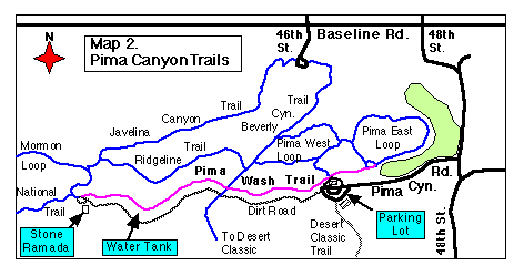
Several trails start at the parking area (see Map 2). The best one for birding is the "Pima Wash" trail, which runs up and down the wash immediately north of the parking lot; this is a relatively mild trail downstream, and contains some short climbs on the upstream portion. A parallel, mildly sloped trail uses an old dirt access road, and starts at the west end of the parking lot; this trail is higher up, and has more people and less of the best habitat. The trail down into the wash starts on either side of the ramada to the north of the parking lot.
The wash can be birded in both directions. Downstream, the trail winds along the sand bottom of the wash with brushy areas of palo verde, ironwood, wolfberry, creosote bush, and other desert shrubs. Abert's Towhee, N. Mockingbird, Mourning Dove, Cactus Wren, Curve-billed Thrasher, Black-tailed Gnatcatcher, Verdin, and Anna's Hummingbird are all found along the wash; Gila Woodpecker and Phainopepla may be found. Rock Wren and Gilded Flicker may be heard and seen on the hillside. White-winged Doves are common in mid- to late summer, after the saguaro fruit ripens. White-crowned Sparrow may be found in winter.
About 200 yards down the wash, the trail approaches the golf course. This area attracts seed-eating species in late fall and winter, including Dark-eyed Junco. American Robin has been seen here. The trail appears to join the paved golf-cart path; the actual park trail is up the hillside above the golf course, and may be followed into the Pima East Loop trail.
Return upstream past the ramada, and continue up the wash. Again, palo verde, ironwood, mesquite, and wolfberry are common along the wash. The same species seen downstream are present; look also for Loggerhead Shrike. Phainopepla are more regular in the upstream portion, as are Cactus Wren. Rock Wren are found in the rocky hillside north of the wash beyond the ramada; they are most often heard, rather than seen. Listen for Costa's Hummingbird while you walk; the male Costa's display whistles are often heard along the wash, and the birds can be seen with patience.
The wash winds generally westward, and the main trail climbs up the north side of the wash onto a flat area. Gilded Flicker may be heard and seen on the saguaros, and Gambel's Quail are often heard where the trail intersects the Beverly Canyon Trail (which runs along a power line crossing the main trail). The Pima Wash Trail rejoins the wash at the Beverly Canyon Trail, and continues winding along. Watch for Rock Wren on the hillsides, and listen for the faint bell-like "tink" note of Black-throated Sparrow (common, but hard to see). Also listen for Ladder-backed Woodpecker, either tapping or sounding a "peek" note; Ladder-backs are more frequently found upstream of the power line.
At about 3/4 mile above the ramada, a cylindrical beige water tank can be seen on the left (south) side of the wash. The water tank feeds a small water trough for wildlife; birds may be attracted to the water, particularly in summer. There are petroglyphs on the rocks northwest of the tank. The trail leaves the wash here, and runs between the dirt road and the south side of the wash for a short distance before dropping back into the wash. Continue on the trail to a fork in the wash; the trail continues to the left and joins the National Trail just below the end of the dirt road.

This junction is a good turn-around point; one can retrace the wash, or return via the dirt road. If a longer hike is desired, several trails offer alternatives. The National Trail climbs up the ridge to the west, and offers very good views of Phoenix, Tempe and the metropolitan area at several viewpoints along the ridge. The Mormon Loop Trail forks from the National Trail a short distance beyond the dirt road, and follows the right-hand branch of Pima Wash for some distance before climbing a ridge toward the skyline. It eventually joins the National Trail, allowing a loop hike. The Ridgeline Trail splits off from the Mormon Loop Trail about 100 yards beyond where the Mormon Loop starts, and provides a higher-level return route to the Beverly Canyon Trail, with good views of Pima Canyon, Phoenix, and Tempe.
As with most desert birding, the best time to bird the area is at dawn. The canyon can heat up quickly, and you should carry a good supply of water, particularly if the longer hikes up the National, Mormon Loop, or Ridgeline Trails are planned.